Coordinate Systems
Only data using select projected and geographic coordinate systems can be shown on a map, regardless of the file format. Files using other systems will be shown, but without a map.
Veta supports the following coordinate systems. The authority and ID recognized for each coordinate system is listed.
- GDA94: EPSG 4283
- GDA2020: EPSG 7844
- GRS80-based systems: EPSG 4019.
This includes NAD 83. Different realizations of NAD are not currently recognized, so use GRS80 for all realizations. Because of this limitation, it is not recommended to mix different systems in the same projects. Such as NAD 83 and NAD 83 (2011). - MGA94: EPSG 28348-28358
- MGA2020: EPSG 7846-7859
- Minnesota County: ESRI 103600-103694
- New Zealand Geodetic Datum 2000 (NZGD2000): EPSG 4167
- New Zealand Transverse Mercator 2000 (NZTM2000): EPSG 2193
- Oregon Coordinate Reference System
- NAD 1983 CORS96 Meters zones from EPSG 6784-6860
- NAD 1986 2011 Meters zones from EPSG 8311-8347
- State Plane: EPSG 3072, 3074, 3088, 3463, 26929-26946, 26949-26998, 32100, 32104, 32107-32130, 32133-32158, 32161
- UTM: EPSG 32601-32660, 32701-32760
Tagged Data File Format
Originally, each manufacturer used a different file format. This requires Veta to have support for each format and to maintain it in the future. To eliminate this, a new standard file format was developed in conjunction with manufacturers. Support for this format was added in Veta 5.2, however Veta does not support every feature of the format. This page documents what is supported by Veta 6 and higher.
Data Headers
Supported blocks
- data-lot-name
- gridding-height
- gridding-process
- gridding-width
- machine-name
- machine-type
- spatial-reference-authority
- spatial-reference-id
Notes
data-lot-name: Naming convention should follow AASHTO PP 80 and PP 81.
gridding-process: gridded or ungridded
machine-type:
- compactor
- paving thermal profiler
- “dielectric profiling system” (preferred) or “rolling density meter” (deprecated)
spatial-reference-authority: EPSG or ESRI
spatial-reference-id: Values below 32767 are EPSG. Values 32767 or higher are ESRI.
Data Source non-array blocks
| Name | Veta version | Notes |
|---|---|---|
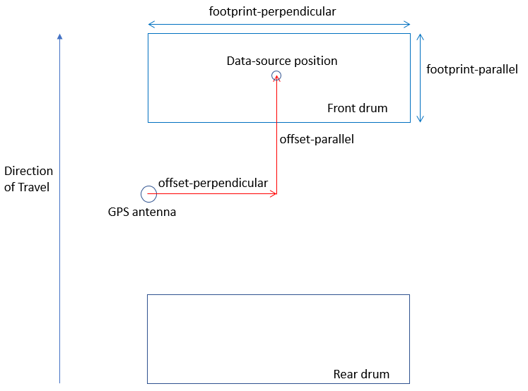
| footprint-parallel | all | |
| footprint-perpendicular | all | |
| height | none | |
| id | 7+ | |
| index | all | |
| measurement-name Caterpillar CMV CCV Dynapac CMV Dynapac E-VIB1 Dynapac E-VIB2 EDV EVIB HMV Leica CMV MCI MDP Topcon CMV Trimble CMV Völkel CMV Volvo CMV |
all all all all all all all all all all all 8 all all 8 all |
Required for compactors using ICMV data. |
| offset-parallel | all | |
| offset-perpendicular | all | |
| offset-name | 7+ | |
| recording-interval | none | continuous is assumed. |
| threshold-maximum | all | |
| threshold-maximum-comparison | all | |
| threshold-minimum | all | |
| threshold-minimum-comparison | all | |
| transformation | none |
Data Source array blocks
| Name | Veta version | Notes |
|---|---|---|
| adjusted-deflection | 6 | |
| air-voids-percent | none | |
| deflection | 6 | |
| density | none | |
| density-percent | none | |
| dielectric | 7+ | |
| easting | all | |
| elevation | none | |
| gps-quality | 7+ | |
| heading | all | |
| icmv | all | |
| icmv-compaction-mode | all | Required for compactors. If missing or empty, the compaction mode for all data will be set to Static. |
| icmv-vibration-amplitude | all | |
| icmv-vibration-frequency | all | |
| jump | none | |
| lift-thickness | none | |
| machine-speed | 6 | |
| northing | all | |
| quality | all | |
| relative-direction | all | |
| resonant-meter-value | none | |
| ride-quality | none | |
| surface-temperature | all |
Offsets and Footprints
footprint-perpendicular, footprint-parallel: Veta uses the same footprint for all data sources in a file, as is done for current file formats. Different footprints for data sources are not currently supported. For ungridded compaction data, only footprint-perpendicular is used. The footprint will be chosen from a prioritized list based on the machine type:
- compactor — the last two sources in the list would not normally have a footprint. However, for a compactor that is only recording position and no other data, the first two sources do not apply.
- icmv
- surface-temperature
- machine-speed
- northing
- paving thermal profiler
- first surface-temperature
- dielectric profiling system
- first dieletric
Quality
Veta uses the term “invalid” to denote measurements that will be ignored. Floating point measurements can and should be marked as invalid by “NaN” values (not a number) as defined by IEEE 754. It is recommended to use this method when possible to reduce file size. For non-floating point measurements or when this method is not desirable, additional blocks are provided:
- quality (array)
- threshold-minimum
- threshold-minimum-comparison
- threshold-maximum
- threshold-maximum-comparison
The thresholds apply to the quality, not the actual measurement value, for more flexibility. The quality can be used as a simple flag (0 or 1), a measured value, or a calculated method. The source does not matter; it is only used in relation to the thresholds.
Because GPS measurements already have a quality flag, the gps-quality block is provided.
Veta supports the following quality methods:
- gps-quality
- NaN
- quality array for Single and Double arrays. For other data types, quality will be ignored and the filtering can be done manually in Veta.
Lookup Tables
All lookup tables are supported.
Measurement Units
All units listed in the specification are recognized except radians.
Verification
We offer a cross-platform application that will read a TDS file and create a text version. It should run on any 64-bit operating system that supports Microsoft .NET 6, although only Windows has been tested.
TDS Verifier 1.0.3 – May 24, 2022
Samples
Files representing 2 of the 3 examples in the specification are included, along with the text output created by the application.
Usage
The program supports four options of parameters:
- input-directory
- input-file
- input-file output-directory
- input-file output-file
Download Veta
Veta is a map-based tool for viewing and analyzing geospatial data. Download Veta for free.
Need help with Veta or are you interested in training?